(엠바고 없음) 수리학 전문가의 대홍수 발생 양상과 원인 분석 전문가 의견 26-107 네팔 돌발홍수와 산사태4 - 홍수 분석
|
|
|
-
- 네팔 돌발홍수의 발생 과정과 추정 원인에 대해, 국내 홍수 전문가의 최신 수리학 분석 내용을 전달합니다.
- 참여 전문가
- 김원 한국건설기술연구원 수자원하천연구본부 선임연구위원
-
- 8월 27~29일 수집했던 기존 전문가 의견도 참고로 첨부했습니다.
|
|
|
기자 여러분은 아래 주의사항을 참고해 활용해주시길 부탁드립니다.
- 엠바고는 없습니다. 자유롭게 활용 가능합니다.
- 되도록 원문을 그대로 활용해주시길 부탁드립니다.
- SMCK를 꼭 인용할 필요는 없습니다. 만약 인용 출처가 필요한 경우, 아래 형식을 따를 수 있습니다.
- "ㅇㅇㅇ(전문가)는 한국과학기술미디어센터에 ㅁㅁㅁ라고 말했다."
|
|
|
김원 한국건설기술연구원 수자원하천연구본부 선임연구위원
*2026.9.2.
*이미지와 그래프, 지도를 포함한 완전한 내용은 여기에서 pdf로 받으실 수 있습니다.
(아래는 일부 내용만 담았습니다.)
2026년 8월 네팔 Trishuli 강 홍수에 대한 수리학적 분석
- 주요 결론
① 최상류 Rasuwagadhi 지점(네팔-티벳 국경에서 9km 하류)에서는 08:40-08:55분 15분 사이 약 12m의 수위 상승, 초당 약 11,000톤의 최대 홍수량 발생, 초당 14m 내외의 유속이 발생하였을 것으로 추정
* 하류 81km Galchhi 지점에서는 10:20-10:50분 30분 사이 8.85m 수위 상승, 하류 100km Maleku 지점에서는 11:10-11:40분 30분 사이 7.13m 수위 상승 발생
* 소양강댐 여수로 설계홍수량 10,500톤/초, 설계방류량 5,500톤/초
② 약 168km 하류 Devghat 지점에서는 약 2,000만 톤의 추가 홍수량 관측
* 네팔 수문기상부(Department of Hydrology and Meteology)는 8월 26일 14:!0-18:00 사이 이 지점의 최고유량을 초당 5,850톤, 기저유량을 초당 2,600톤, 총 통과 유량을 약 57.4백만 톤, 기저유량을 제외화 초과 홍수량을 19.96백만 톤으로 추정
* 이 수치는 상류에 약 2,000만 톤의 물을 공급할 수 있는 저수지가 있었다는 것을 의미함
③ 아직까지 약 2,000만 톤의 물을 공급할 수 있었던 저수지, 빙하 등에 대해서는 정확한 분석이 이루어지지 않고 있음
④ 이번 극한홍수의 원인은 약 2,000만 톤의 자연 저수지 존재 → 대규모 빙하 추락 → 저수지 붕괴 → 댐붕괴와 유사한 형태의 극단적 홍수 발생으로 추정
2. 피해 사진
생략(원문 pdf 참조)
3. 발생 개요
생략(원문 pdf 참조)
4. 홍수 전파
생략(원문 pdf 참조)
5. 홍수 규모
생략(원문 pdf 참조)
6. 홍수 발생 원인 추정
생략(원문 pdf 참조)
7. 시사점
- 전혀 예상할 수 없었던 극단적 상황 발생
- 우리나라에도 대규모 댐, 중소규모 저수지가 많은 상황(약 18,000여개)
- 극단적 강우 등에 의해 상상할 수 없는 상황 발생 가능
- 제방 붕괴 등으로 인해 도시에서도 발생 가능
- 이런 상황에 대비하기 위해서는
① 극단적 상황 발생에 대비한 사회적 대응 체계 구축
② 취약지구(대규모 인구 밀집 지역, 대규모 지하공간 등)에 대한 면밀한 대책 필요
wonkim@kict.re.kr |
|
|
아래는 네팔 대홍수 관련해 8월 27~29일 수집한 전문가 의견입니다. SMCK 홈페이지에서도 보실 수 있습니다. |
|
|
이원상 극지연구소 빙하지권연구본부 책임연구원
*2026.8.29.
이번 네팔 홍수는 빙하호가 터진 사건(GLOF)이 아니다. 초기에는 지진이 붕괴를 일으켰다는 분석이 있었으나, 미국지질조사국(USGS)은 그 신호가 지진이 아니라 붕괴 자체가 만들어낸 산사태 진동이었다고 재분류했다. 다만 이것은 그 신호의 정체에 대한 판단이지 지진의 관여가 배제됐다는 뜻은 아니며, 국제산악통합개발센터(ICIMOD)도 인과관계는 아직 확립되지 않았다는 입장이다. 확인된 것은 해발 5,200미터 부근에서 사면이 대규모로 무너져 곧바로 토석류(debris flow)가 됐다는 사실이다. 위성 분석이 추가되면서 그 순서는 기반암이 먼저 무너지고 그 위에 얹혀 있던 빙하 말단(끝부분)이 함께 쓸려 내려온 쪽으로 좁혀지고 있으며, 이 정도 규모의 붕괴에는 이러한 해석이 물리적으로 보다 타당하다. 이미 형성돼 있던 빙하호가 터진 것이 아니기 때문에, 빙하호의 수위와 제방 상태를 감시하는 방식의 조기경보로는 이러한 돌발적인 붕괴를 포착할 수 없다. 대비 설계 자체가 달라져야 한다는 뜻이다.
이 재난의 성격을 규정하는 것은 시간이다. 붕괴는 8월 26일 오전 8시 37분(현지시각)에 일어났고, 7분 뒤인 8시 44분 국경의 지룽 검문소가 파괴됐다. 하류에서 이상을 감지해 경보를 발령하고 주민을 대피시키는 통상의 절차로는 감당할 수 없는 시간이다. 국경 지역에서 문제는 위험을 감지하고도 대피로 이어지지 못한 데 있는 것이 아니다. 감지에서 대피까지의 전 과정에 주어진 시간이 단 7분이었다.
그러나 관측 대상을 달리하면 이야기가 달라진다. 재난 대응에서 실무적으로 가장 중요하다고 판단하는 지점이 여기에 있다. 붕괴는 그 자체로 지진파를 만들고, 지진파는 토석류와 비교할 수 없이 빠르다. 공개된 광대역 지진 자료를 예비적으로 검토해 보면, 이 붕괴는 무너지기 시작한 직후부터 신호를 냈고, 주변 관측망의 배치에 따라 수 초에서 수십 초 안에 탐지가 가능한 수준이었다. 1,200킬로미터 밖 관측소에서도 배경잡음의 100배 이상으로 기록됐다. 반면 토석류가 하류에 닿기까지는 시간이 걸렸다. 국경에서 7분이었던 것이 베트라와티 수위관측소까지는 43분, 데브가트까지는 다섯 시간이었다. 더구나 지진 관측은 빙하호든 암반이든 사면이 크게 움직이는 순간 자체를 포착하므로 진원의 형태나 종류를 가리지 않는다. 관측망도 신호도 이미 있다. 없는 것은 그 신호를 긴급조기경보의 출발점으로 삼는 운영 체계다.
기후변화를 이번 붕괴의 직접 원인으로 단정할 수는 없다. 다만 온난화가 사면을 지탱하던 얼음의 양을 감소시키고, 얼고 녹는 주기를 변화시키면서 고산 사면의 안정성을 지속적으로 낮추고 있다는 점은 분명하다. 그 결과 이런 붕괴는 뚜렷한 방아쇠 없이도 일어날 수 있는 상태가 된다. 이번 사건에서도 방아쇠라 할 만한 것은 아직 확인되지 않았다. 네팔 수문기상국에 따르면 붕괴 당일 라수와 일부 지역의 24시간 강우량은 7밀리미터 미만이었다. 몬순기였음을 감안하면 매우 적은 양이다.
관측이 있고 없고의 차이는 이번 사건 안에서 이미 한 차례 확인됐다. 붕괴로 하천이 막혀 생긴 언색호가 28일 실제로 터졌다. 그러나 이번에는 2차 홍수가 발생할 것을 미리 알고 있었다. 호수의 존재와 저수량이 파악돼 있었고, 하류 주민은 이미 대피한 상태였으며, 구조 작업도 중단됐다. 같은 유역에서 한 주 사이에 두 번의 붕괴가 있었다. 첫 번째는 7분을 주었고, 두 번째는 하루가 넘는 시간이 있어 대비가 가능했다. 차이는 그 자리에 위험이 있다는 것을 알고 있었느냐였다.
가장 큰 문제는 26일 아침에 무너진 사면이 감시 대상이 아니었다는 점이다. 우리는 이미 알고 있는 재난에 대비한다. 붕괴 기전은 현장 정밀조사를 거쳐야 확정되고 붕괴 체적도 추정치가 엇갈리지만, 그와 무관하게 분명한 것이 하나 있다. 앞으로 대비해야 할 재난이 이런 형태라면, 지정된 위험 지점을 감시하는 방식만으로는 부족하다. 어디가 위험한지 모르는 상태에서도 무언가 크게 무너졌다는 사실만큼은 즉시 알 수 있어야 한다.
wonsang@kopri.re.kr |
|
|
오재호 나노웨더 대표・부경대 명예교수
*2026.8.29.
|
|
|
아래는 28일(현지시간) 영국 SMC가 수집한 추가 전문가 의견입니다. 영국 SMC 홈페이지에서도 보실 수 있습니다. |
|
|
On the barrier lake:
Prof Maria Shahgedanova, Professor of Climate Science at the Department of Geography and Environmental Science, University of Reading, said:
“We now believe that the Rasuwa flood was triggered by a large rock and ice avalanche at around 5,200m above sea level, when a huge section of glacier and the underlying bedrock, estimated to be between 1 and 1.3km wide, detached from the Lirung massif.
“The avalanche rapidly carried large volumes of ice, rock and sediment downslope. On reaching the valley floor, it interacted with deposits from a previous flood, the 2025 Purepu glacial lake outburst flood, temporarily damming the river. The failure of this temporary blockage released water and debris as a powerful flood wave.
“Researchers from the HiRisk project, which investigates cryosphere-related hazards in High Mountain Asia, suggest that longer-term glacier retreat and permafrost degradation may have contributed to slope destabilisation. The failed glacier retreated by approximately 450m between 1990 and 2020, potentially reducing the mechanical support provided by the glacier to the underlying rock slope. Permafrost degradation may have further contributed to instability. The warmer than average temperatures observed in the area this summer might have contributed to the glacier collapse too, although observations at these elevations remain limited.
“The event demonstrates how climate-driven changes in the cryosphere can change conditions that make hazards in high-mountain regions even more risky for people in the area. Such events cannot be prevented, but their impacts can be reduced through systematic hazard assessment and monitoring. High-resolution satellite observations and InSAR, a type of satellite-based radar that detects small changes in the earth’s surface, can identify changes in glaciers and slope stability and contribute to early-warning systems, particularly in remote mountain regions where conventional monitoring is limited. While the initial avalanche at Rasuwa was too rapid to provide substantial warning, longer warning times downstream could potentially have reduced loss of life.”
Prof Reza Ahmadian, Professor of Water and Environmental Engineering, Cardiff University, said:
1. What is a barrier lake, how has it formed and where has it formed?
“A barrier lake which is also referred to as landslide dammed lake or debris dammed lake, forms when material suddenly blocks the natural flow of a river or stream. Unlike a conventional reservoir, the dam has not been designed, built and engineered. It consists of naturally deposited material, and its geometry, internal structure and stability is therefore highly uncertain.
“In this particular event, the evidence currently indicates that a major glacial collapse and associated ice and rock avalanche occurred on 26 August in the high mountains near the Nepal China border. The USGS has located the source on a glaciated mountain cliff on the northern side of Langtang Lirung. The collapsing ice and rock moved downslope, entraining water, sediment and additional debris and producing the destructive debris flow and flood that subsequently travelled through the river system.
“Part of this material blocked or substantially restricted river channels, allowing water to accumulate behind the debris and creating natural barrier lakes.
“The lake that has received most attention is reported near the confluence of the Chhochen Khola and Purepu Tsangpo rivers, upstream of the Bhotekoshi river system near the Nepal China border. These rivers ultimately feed into the Bhotekoshi and then the Trishuli river system.
“One important point is that this should not simply be described as an ordinary glacial lake. It is a newly formed barrier lake associated with the deposition of ice, rock, sediment and debris following the collapse. Its size can increase rapidly as it has blocked natural flow and its stability is uncertain.
2. What is the likelihood that it will overflow or breach its banks?
“As far as I understand, there are reports that indicate that overflow has already occurred, and there have also been reports of a breach or partial release.
“There is clearly a significant risk, but at present it would not be scientifically responsible to attach a precise probability to a breach. These natural dams are made from an irregular mixture of rock, sediment and ice rather than engineered materials, and their internal structure is not well known. The risk depends on how quickly water is entering the lake, how quickly it can escape, the geometry and composition of the blockage, erosion of the overflow channel and whether further landslides or ice and rock falls occur.
“It should be noted that overflow does not necessarily mean catastrophic failure. Water can establish a relatively stable outlet and progressively lower the lake. Conversely, overflow can erode unconsolidated debris, deepen the outlet and produce a rapidly enlarging breach. That distinction is critical.”
3. What could happen if the barrier lake breaches its banks?
“The principal concern is a sudden release of stored water, producing another flood wave downstream.
“The severity would depend on the volume of water released, how rapidly the breach develops, the size and geometry of the opening, the amount of sediment and debris entrained, and the shape and gradient of the downstream valley.
“A rapid breach could generate a high velocity flood containing water, sediment, boulders and woody or structural debris. In a steep confined Himalayan valley, such a flow can be particularly destructive. It could threaten settlements and people along the river corridor and damage roads, bridges, hydropower infrastructure and other structures.
“The areas of immediate concern are along the Bhotekoshi and subsequently the Trishuli river system. Nepalese authorities have already reported increases in Bhotekoshi water levels associated with releases from the lake.
“There is also the possibility of a cascading hazard. A flood wave can erode riverbanks and valley sides, mobilise additional sediment, destabilise slopes and create further temporary blockages downstream. So the hazard is not necessarily limited to the volume of water initially stored in the lake.
“The scale should nevertheless not be exaggerated. A breach of the present barrier lake would not automatically reproduce the extraordinary event of 26 August. The original event involved a major glacial collapse followed by a debris flow and flood that the USGS estimates travelled approximately 100 kilometres. The consequences of a new breach depend on the actual volume released and the way in which the natural dam fails.”
4. Is it possible to predict when that may happen?
“Not with precision. It is not currently possible to predict the exact time at which a natural barrier might fail. These barriers are composed of irregular mixtures of rock, sediment, ice and other debris, and their behaviour can change quite rapidly as water levels rise and water begins to flow through or over the material.
“What we can do, however, is continuously monitor the conditions that could indicate an increasing likelihood of failure. This includes changes in lake level, inflow and outflow, deformation or erosion of the barrier, and changes in downstream river levels. Satellite observations, aerial surveys, cameras, drones and river monitoring stations can all contribute to this. Nepalese authorities are currently monitoring two lakes and are planning additional cameras and sensors downstream. One lake seems to be draining, while the second, larger lake seemed to be growing and had no visible outlet in the latest satellite observations.
“Hydraulic modelling is also extremely important. We may not be able to say precisely when the barrier will fail, but we can model a range of possible failure scenarios and estimate how much water could be released, the resulting peak discharge, flood depths and velocities, the areas that could be inundated, and critically, how long the flood wave could take to reach different communities downstream.
“This information should feed directly into evacuation planning. Rather than waiting until we know that the barrier is about to fail, which may provide very little warning, authorities can identify vulnerable areas in advance, determine which communities and critical facilities need to be evacuated, identify safe areas on higher ground, establish evacuation routes and define the warning thresholds that would trigger evacuation.
“An important consideration in this particular event is that roads and bridges have already been severely damaged. Therefore, evacuation planning cannot assume that normal transport routes will remain available. Alternative routes, safe assembly points and arrangements for people who may require assistance all need to be considered. Rescue and relief personnel working close to the river are themselves also exposed and need to be incorporated into the evacuation plan.
“There is also a strong case for precautionary evacuation where the potential consequences are severe, and the warning time is uncertain. Authorities do not necessarily need to wait for confirmation that a complete breach has begun. If monitoring indicates a significant increase in risk, moving people away from the river corridor and onto higher ground can substantially reduce the potential loss of life.
“The key point is that although we cannot reliably predict the exact time of failure, we can predict possible consequences and approximate flood travel times. That allows emergency planners to work backwards from the time available and establish when warnings and evacuations need to take place.
“In a situation such as this, good forecasting is therefore not simply about predicting the flood. It is about converting monitoring and modelling information into decisions early enough for people downstream to reach safety.
Declared interests
Prof Maria Shahgedanova: "no conflicts to declare"
Prof Reza Ahmadian: “no conflicts of interest”
|
|
|
아래는 27일 수집한 기존 전문가 의견 및 해외 SMC 전문가 의견입니다. SMCK 홈페이지에서도 보실 수 있습니다. 시시각각 사태에 대한 정보가 변화하고 있으니 시점에 유의해서 참고해주시길 부탁드립니다. |
|
|
최명기 대한민국산업현장교수단 교수
*2026.8.28.
Q1. 생존자 구조와 피해 복구를 위해 유의해야 할 점은 무엇일까요.
구조 단계에서 가장 경계해야 할 것은 2차 붕괴다.
1) 드론 선발대 - 인력 후발대 이원화 체계다. 구조인력이 현장에 진입하기 전 먼저 소형 드론 편대를 투입해 열화상 카메라로 생존자의 체온 신호를 탐지하고 동시에 지형 변위 센서가 장착된 정찰 드론으로 구조대가 이동할 경로의 지반 안정성을 실시간으로 스캔한다. 드론이 이 경로는 30분 내 붕괴 위험 낮음이라는 신호를 준 구간부터 인력을 순차 투입하는 방식이다. 이는 사람이 먼저 위험을 감수하며 정찰하던 기존 방식을 뒤집는 것이다.
2) 구조대원 개인에게 이탈 임계선(trip-line) 개념을 부여하는 것이다. 각 구조대원의 안전장비에 상류 방향 진동·수위 변화를 감지하는 소형 센서를 부착하고 사전에 설정한 임계값을 넘으면 개인 단말기에 즉시 경보가 울리며 자동으로 상급 지휘부에도 위치와 상황이 전송되도록 한다. 지휘부가 무전으로 전원 철수를 외치기 전에 현장에서 개인 단위로 즉각 반응할 수 있는 마지막 안전판을 만드는 것이다.
3) 2인 1조 앵커링 수색이다. 급류나 불안정한 토사 지역에서는 구조대원 두 명이 로프로 서로를 연결하고 반드시 한 명은 고정된 지형지물(암반, 나무, 사전 설치한 앵커 말뚝)에 확보 상태를 유지한 채로만 다른 한 명이 전진하는 방식을 원칙화한다. 이는 산악 등반의 빌레이 기법을 재해 수색에 그대로 적용하는 것으로 한 명이 발을 헛디디거나 지반이 꺼져도 즉시 제동이 걸린다.
4) 음향 반향 수색을 병행하는 것이다. 토사에 매몰된 생존자를 찾을 때 구조견이나 인력이 직접 파헤치며 접근하는 대신 지진파 탐지에 쓰이는 지중 음향센서를 격자형으로 배치해 미세한 반응(두드림, 심장박동 유사 진동)을 먼저 포착하고 반응이 확인된 지점만 정밀 굴착하는 방식이다. 이렇게 하면 구조인력이 불안정한 대규모 토사더미 전체를 무작정 밟고 다니는 위험을 줄이면서도 수색 효율을 높일 수 있다.
5) 구조 현장에 실시간 위험지수 전광판을 운영하는 것이다. 상류 감시 데이터(강우량, 수위, 지반 변위)를 종합해 시시각각 변하는 위험지수를 현장 지휘소에 신호등처럼 표시하고 이 지수가 일정 수준을 넘으면 어떤 상황에서도 예외 없이 전원 철수하는 규칙을 사전에 명문화해 둔다. 구조 현장에서는 조금만 더 찾으면 될 것 같다는 심리적 압박 때문에 위험 신호를 무시하는 경우가 실제 재난 대응에서 반복적으로 나타나는 문제인데 이를 사람의 판단이 아닌 기계적 기준으로 강제하는 장치가 필요하다.
6) 실종자 본인의 마지막 신호를 역설계하는 방법이다. 만약 실종자가 스마트워치나 스마트폰을 소지하고 있었다면 사망 직전이 아니라 마지막으로 정상 신호가 잡혔던 시점의 위치와 그 이후 몇 분간의 가속도계·자이로 데이터를 분석해 급류에 휩쓸린 방향과 속도를 역산할 수 있다. 이를 통해 넓은 하류 지역 전체를 훑는 대신 물리적으로 도달 가능한 범위로 수색 구역을 좁혀 구조대의 노출 시간과 위험 구간 자체를 최소화하는 것이 가능하다.
7) 산사태·홍수가 발생했다는 사실 자체는 상류 지형이 이미 불안정한 임계 상태에 있었음을 보여주는 증거이다. 따라서 구조대가 하류에 진입하는 동안에도 상류 상태를 드론이나 위성 영상으로 실시간 감시하는 별도 인력을 배치해야 한다. 이런 감시 체계 없이 구조대가 무작정 현장에 진입하면 구조자 자신이 다음 붕괴의 피해자가 될 수 있다. 실제로 2021년 인도 차모리 산사태 당시에도 구조 도중 여진성 낙석으로 구조인력이 다친 사례가 있었다.
8) 접근로가 끊긴 상황에서는 전면적 진입보다 단계적 거점 확보 방식이 유효하다. 헬기로 확보 가능한 거점 몇 곳을 먼저 세우고 그 사이를 임시 도보로나 로프웨이로 연결해 단계적으로 반경을 넓혀가면 안전성과 속도를 동시에 확보할 수 있다. 통신이 두절된 인력을 찾을 때는 무작정 넓은 지역을 수색하기보다 마지막으로 확인된 통신 신호나 GPS 로그 지점을 기준으로 토사·물의 이동 방향을 역산해 수색 우선순위 구역을 좁히는 방법이 골든타임 내 생존 확률을 높일 수 있다.
Q2. 한국에서도 향후 대형 홍수나 산사태가 발생할 위험이 있을까요. 그렇다면 예방을 위해 준비할 부분은 무엇일까요.
우리나라는 빙하가 없어 이번 네팔 사태와 같은 빙하호 붕괴형 재난이 직접 발생할 가능성은 낮다. 그러나 이를 근거로 안심할 수 있는 상황은 아니다. 최근 몇 년간 국지성 집중호우와 극한강우의 빈도·강도가 뚜렷이 늘어나면서 산지와 계곡부의 급경사지 붕괴, 돌발홍수 위험은 이미 국내에서도 현실화되고 있다.
최근 거제 산사태를 비롯하여 2020년 이후 반복된 여름철 시간당 100mm 이상의 극한호우와 이에 따른 산사태·계곡부 침수 피해는 이러한 흐름을 뒷받침한다. 즉 원인은 다르지만 짧은 시간에 좁은 지형으로 막대한 수량과 토사가 집중되어 하류를 덮치는 재해 메커니즘 자체는 한국에서도 충분히 재현될 수 있다.
특히 위험도가 높은 지점은 세 가지로 요약할 수 있다.
1) 협곡형 계곡 지형에 위치한 소규모 마을과 펜션·야영지다. 평상시에는 경관이 뛰어나 관광지로 개발되지만 집중호우 시 상류의 수위 변화가 몇 분 만에 하류에 도달하는 구조적 취약성을 그대로 지니고 있다.
2) 산지 인접 대규모 건설현장이다. 이번 네팔 사고처럼 계곡부에 위치한 수력발전소, 도로, 터널 공사 현장은 접근성이 떨어지는 만큼 재해 발생 시 고립과 통신 두절의 위험이 크다.
3) 산사태 위험지구로 지정되었으나 정비가 미뤄진 노후 사면이다. 기후위기로 강우 패턴이 변화하는 속도가 기존 위험지구 지정 및 정비 계획의 속도를 앞지르고 있다는 점도 함께 고려해야 한다.
예방을 위해 준비할 부분은 다음과 같다.
1) 계곡·급경사지 인접 시설에 대한 조기경보체계를 실질적으로 작동시켜야 한다. 상류 강우량과 수위를 실시간으로 계측해 하류 시설에 자동으로 경보를 전달하는 체계는 이미 일부 구축되어 있으나 실제 재난 상황에서 경보가 주민의 대피 행동으로 이어지지 못하는 경우가 반복되어 왔다. 경보 발령 이후 대피까지의 절차를 정례적으로 훈련하는 것이 장비 구축 못지않게 중요하다.
2) 산악·계곡 지형에 위치한 건설현장에 대해서는 통신 두절 상황을 전제로 한 별도의 안전관리 기준을 마련해야 한다. 이번 네팔 사고에서 드러났듯 재해 발생 시 가장 먼저 끊기는 것이 통신이다. 위성통신 등 지형에 구애받지 않는 비상연락 수단을 상시 확보하고 정기적인 통신 두절 대응 훈련을 실시하는 것이 필요하다.
3) 기존의 산사태 위험지구 지정과 정비 계획을 현재의 강우 패턴 변화 속도에 맞추어 재평가해야 한다. 과거 강우 통계를 기준으로 설정된 위험도 등급이 최근의 극한강우 빈도를 충분히 반영하지 못하고 있다면 정비 우선순위 자체를 다시 산정할 필요가 있다.
4) 지역 주민의 경험적 지식을 방재 자료로 축적하는 체계를 갖추어야 한다. 계측 장비만으로는 포착하기 어려운 국지적 위험 신호는 그 지역에 오래 거주한 주민들의 관찰에서 나오는 경우가 많다. 이러한 구술 정보를 정기적으로 수집하고 기록해 지자체의 방재 계획에 반영하는 절차를 제도화할 필요가 있다.
5) 역방향 경보 체인을 만드는 것이다. 지금의 조기경보는 대개 관측소에서 하류로 일방향 전달되는 구조인데 협곡 지형에서는 관측소 자체가 재해에 휩쓸릴 수 있다. 대신 하류의 여러 마을이 서로를 감시하는 사슬 구조를 만들면 어떨까. 즉 A마을이 이상 징후(강물 색깔, 굉음, 수위)를 감지하면 즉시 하류 B마을에, B마을은 다시 C마을에 릴레이식으로 경보를 전달하는 방식이다. 통신망이 끊겨도 마을 간 육성·사이렌·봉화 같은 원시적 수단을 병행하면 최소한의 시간을 벌 수 있을 것 같다.
6) 생체신호 기반 조기 감지를 활용하는 방법을 고민해야 한다. 고가의 센서망을 촘촘히 깔기 어려운 산악 지역에서는 계곡 인근에 서식하는 동물들의 이상행동(가축의 동요, 조류의 집단 이동)을 감지하는 저비용 관찰 체계를 방재 시스템에 결합할 수 있다. 실제로 여러 문화권에서 대형 재해 전 동물의 이상행동이 보고된 사례가 있으며 이를 정식 경보 체계의 보조 지표로 공식화하는 시도는 아직 드물다.
7) 분산형 임시 대피 캡슐을 계곡 요소요소에 미리 설치하는 것이다. 대피소까지 이동할 시간이 없는 돌발재해 특성상 마을에서 도보 1~2분 거리마다 소형 방수·내충격 캡슐형 대피 구조물(마치 산불 대피용 쉘터의 홍수판)을 지형이 높은 지점에 분산 배치하면 대피로 확보가 어려운 초기 구조가 될 때까지 몇 분간을 버틸 수 있다.
8) 건설현장에는 자동 이탈형 부표 추적기를 도입하는 것이다. 이번 네팔 사고처럼 인력이 급류에 휩쓸려 실종되는 경우 작업자가 상시 착용한 안전벨트나 헬멧에 GPS 부표가 내장되어 있어 충격이나 침수 감지 시 자동으로 분리되어 물 위로 떠오르며 위치를 송신하는 장비를 표준 안전장비화하는 방안이다. 산악 건설현장처럼 통신 인프라가 취약한 곳일수록 위성 기반 저전력 위치추적 기술의 도입 필요성이 크다.
9) 재해 이후 지형 기억 지도를 디지털로 남기는 것이다. 이번 사고로 토사가 이동한 경로, 유속, 파괴 범위를 드론과 위성으로 정밀 기록해두면 향후 유사 지형에서 재해가 발생했을 때 확산을 예측하는 시뮬레이션 모델의 학습 데이터로 쓸 수 있다. 개별 재해를 일회성 기록이 아니라 다음 재해 예측을 위한 데이터 자산으로 축적하는 발상의 전환이 필요하다.
10) 국경을 넘는 실시간 데이터 공유 협정이다. 이번 사고는 티베트에서 발원해 네팔로 넘어온 초국경 재해였다. 상류국의 관측 데이터가 하류국에 실시간으로 공유되지 않으면 아무리 좋은 경보체계를 갖춰도 무용지물이 된다. 히말라야처럼 여러 국가가 하나의 수계를 공유하는 지역에서는 정치적 관계와 무관하게 자연재해 관측 데이터만큼은 즉시 공유하는 별도의 재해 데이터 중립지대 협정을 국제기구 주도로 제도화하는 방안을 검토할 만하다.
이번 네팔 사태가 한국에 주는 시사점은 재해의 발생 원인이 다르더라도 좁은 지형에 재난이 집중되는 구조적 취약성과 그로 인한 대응 시간의 부족이라는 문제는 공통적으로 존재한다는 것이다. 예방의 핵심은 새로운 장비를 도입하는 것 못지않게 이미 갖춰진 체계가 실제 위기 상황에서 작동하도록 훈련하고 점검하는 데 있다.
c95019@naver.com |
|
|
조천호 전 국립기상과학원장
*2026.8.28.
IPCC 6차 평가보고서(AR6 WG II)에 따르면, 히말라야 지역에서 가동 중이거나 건설·계획 중인 수력발전 프로젝트의 약 3분의 2가 잠재적인 빙하호 붕괴 홍수(GLOF) 경로 위에 놓여 있다. 이 가운데 최대 3분의 1은 설계 기준을 넘어서는 규모의 홍수를 맞을 수 있는 것으로 분석됐다. 빙하가 후퇴하고 새로운 빙하호가 늘어날수록, 빙하와 호수에 가까운 상류를 향해 올라가는 수력발전 개발의 위험은 그만큼 커진다는 것이 보고서의 결론이다.
이런 재난은 이미 현실이 되고 있다. 2023년 인도 히말라야 지역에서는 빙하호 붕괴로 인해 수력발전소들이 도미노처럼 쓰러졌다. 댐 하나는 붕괴되었고 그 아래 댐은 침수와 토사 매몰 피해을 당했다. 건설 중이던 수력 발전소는 공사 현장이 유실되었다. 2024년 네팔에서도 빙하호 붕괴로 인한 피해을 입었다.
2026년 8월 26일 네팔 빙하호 붕괴 홍수는 한국 기업이 주도해 짓던 어퍼트리슐리-1까지 덮쳤다. 이 사업은 총사업비 약 6억4,700만 달러 규모의 수력발전 사업이다. 공정률은 약 84%까지 올라 있었다. 그러나 홍수로 상당 부분 파손되어 준공과 상업운전 일정에는 상당한 차질이 불가피해졌다.
완공한다 해도 기온이 계속 오르는 한 위험은 더 커진다. 국제산악통합개발센터(ICIMOD)의 2019년 힌두쿠시-히말라야 평가는 지구 평균온도 상승을 1.5도로 제한하더라도 세기말까지 이 지역 빙하 부피의 약 3분의 1이 손실될 것으로 전망했다. 온실가스 배출이 현재 추세로 이어진다면 손실은 3분의 2로 커진다.
기후 리스크를 설계 조건에 반영하지 않은 인프라가 어떤 대가를 치르는지, 어퍼트리슐리-1은 그 자체로 보여준다. 기후위기는 이제 인프라 사업에서 환경 문제이기 전에 안전과 수익의 문제다.
cch0704@gmail.com |
|
|
오재호 나노웨더 대표・부경대 명예교수
*2026.8.27.
이번 네팔 돌발홍수는 단순히 많은 비가 내려 강물이 불어난 일반적인 홍수라기보다, 고산지대에서 거대한 빙하와 암석이 무너지면서 물·얼음·토사가 한꺼번에 계곡을 휩쓴 복합 산악재해이다. 지구온난화가 계속되면 산악빙하는 점차 얇아지고 균열이 많아진다. 동시에 빙하 아래와 주변 산비탈을 오랫동안 얼어붙게 했던 영구동토층도 녹으면서, 빙하와 암반을 붙잡아 주던 힘이 약해진다. 이렇게 오랜 기간 불안정해진 빙하와 암석이 어느 순간 대규모로 붕괴하면 엄청난 양의 얼음과 토사가 좁고 가파른 계곡으로 순식간에 쏟아져 내려간다. 이 과정에서 하천이 일시적으로 막혔다가 다시 터지면 거대한 급류와 토석류가 발생해 하류 마을을 매우 짧은 시간에 덮칠 수 있다.
다시 말해서, 온난화 → 빙하·영구동토 약화 → 빙하·암석 붕괴 → 하천 막힘 → 임시 댐 붕괴 → 대규모 돌발홍수라는 연쇄 과정으로 이해할 수 있다. 특히 중요한 점은 온난화와 빙하 약화는 수십 년에 걸쳐 천천히 진행되지만, 실제 붕괴와 홍수는 수분에서 수십 분 사이에 일어날 수 있다는 것이다. 기후변화가 느리게 진행된다고 해서 재난도 느리게 오는 것은 아니다.
이번 한 사건을 곧바로 기후변화가 직접 일으켰다고 단정하기에는 추가 조사가 필요하다. 그러나 지구온난화가 빙하와 영구동토층을 약화해 이러한 대규모 산악재해가 발생하기 쉬운 환경을 만들고 있다는 점은 매우 분명하다. 이와 같은, 이른바 ‘빙하 쓰나미’에 비유할 수 있는 급격한 연쇄 재해는 네팔뿐 아니라 히말라야의 다른 계곡, 유럽 알프스, 남미 안데스 등 산악빙하가 존재하는 지역에서도 앞으로 더욱 주의 깊게 감시해야 할 새로운 기후재난 위험이다.
jjho2023@gmail.com |
|
|
진경 극지연구소 정책협력부장・세계기후연구계획(WCRP) 기후와 빙권(CliC) 과학운영위원회 위원
*2026.8.27.
이번 재난의 직접적인 원인을 기후변화와 곧바로 연결 짓기에는 정밀한 원인 규명과 귀인 분석이 필요하다. 그러나 전 지구적 온난화와 함께 빙하가 빠르게 후퇴하면서 빙하호 붕괴홍수, 대규모 얼음사태, 빙하성 토석류 등 새로운 위험이 발생하거나 기존 위험이 증폭되고 있다는 점은 주목해야 한다. 실제로 2000~2023년 전 세계 빙하는 연평균 약 2,730억 톤의 질량을 잃었으며, 2022~2024년에는 관측 이래 가장 큰 3년 연속 빙하 질량 손실을 기록했다.
더 주목해야 할 점은 이러한 고산 빙권의 변화가 산악지역에만 머물지 않는다는 사실이다. 히말라야와 티베트고원을 포함하는 이른바 ‘제3의 극지’는 아시아 주요 하천의 발원지로, 이곳에서 시작되는 하천들은 약 20억 명에게 필수적인 물을 공급한다. 따라서 고산 빙하의 변화는 단순한 얼음의 소실을 넘어, 산악지역에서 시작된 위험이 하천을 따라 하류의 인구와 사회기반시설로 전달되는 ‘연쇄적 영향’의 관점에서 바라볼 필요가 있다.
참고자료
WMO, Glacier melt will unleash avalanche of cascading impacts
WMO, Glaciers and Ice Caps
UN-Water & UNESCO, The United Nations World Water Development Report 2025: Mountains and Glaciers – Water Towers
jin@kopri.re.kr |
|
|
최명기 대한민국산업현장교수단 교수 (27일 1차 의견)
*2026.8.27.
이번 참사는 위험이 조용히 쌓이다가 어느 한순간 걷잡을 수 없이 터져 나온 사고다. 보도에 따르면 해발 5,200m 고지에서 거대한 빙하 덩어리가 무너져 내렸고 이 얼음과 바위가 강을 막아 일종의 '임시 댐'을 만들었다. 이 댐이 무너지면서 그동안 갇혀 있던 물과 흙, 돌이 한꺼번에 하류로 쏟아진 것으로 보인다. 실제로 트리술리강 하류에서는 불과 30분 만에 수위가 9m나 상승했다. 건물이 무너질 때 위험이 서서히 쌓이다 한순간에 터지는 것과 같은 원리가 자연에서는 이런 방식으로 나타난 셈이다.
기후위기는 바로 이 '임시 댐의 재료'인 빙하 자체를 점점 불안정하게 만들고 있다. 히말라야 지역에서 빙하가 원인이 된 홍수는 2000년대만 해도 5~10년에 한 번 정도였으나 최근에는 한 해에도 여러 차례 발생할 만큼 잦아지고 있다. 위험이 일어나는 빈도 자체가 달라지고 있는 것이다.
가장 안타까운 지점은 '위험을 감지하는 것'과 '사람을 실제로 대피시키는 것' 사이의 간극이다. 무너지기 전에는 크든 작든 이상 징후가 나타나기 마련이나 이를 곧바로 대피 행동으로 옮기지 못하면 참사로 이어진다. 국내 여러 붕괴 사고에서도 반복적으로 확인된 패턴이다.
대응책은 예측-예방-감시-경보-대피의 다섯 단계를 하나의 체계로 통합해 갖춰야 한다. 우선 유역 단위의 통합 수방대책이 선행되어야 한다. 상류의 빙하호·계곡·급경사지 같은 위험원과 하류의 주거지·도로·교량·관광시설을 하나의 유역으로 묶어 홍수위험지도를 작성하고 위험원별로 정기적인 재해영향평가를 실시해 어느 지점이 임계 위험 구간인지 사전에 특정해 두어야 한다. 이런 기초 조사 없이 계측기만을 설치하는 것은 어디에 무엇을 감시해야 하는지 모른 채 계측 장비를 늘어놓는 것과 다르지 않다.
감시 단계에서는 상류 취약 구간에 초음파식·레이더식 수위계, 지반 변위계, 진동·음향 센서 등을 IoT 방식으로 설치해 실시간 원격 전송 체계를 갖추어야 한다. 특히 빙하호나 얼음사태처럼 접근이 어려운 고지대는 위성·드론 영상과 지상 센서를 함께 활용하는 빙하호 붕괴 홍수(Glacier lake outburst flood, GLOF) 특화 조기경보체계가 필요하다. 이렇게 수집된 실시간 자료는 유역별 홍수추적모형(수리·수문 모델)에 입력해 상류에서 이상 신호가 발생했을 때 그 물이 하류 특정 지점까지 도달하는 데 걸리는 시간, 즉 홍수 도달시간을 사전에 산정해 두어야 한다. 여기에 실시간 수문 자료를 지속적으로 반영해 갱신되는 인공지능 기반 수위 예측 모델을 결합하면 통상적인 강우성 홍수와 이번처럼 빙하 붕락·산사태에서 비롯한 돌발홍수를 구분해 대응 강도와 경보 단계를 차등화할 수 있다.
다만 아무리 정교한 감시·예측 체계를 갖추어도 그 신호를 즉각적인 행동으로 전환하는 비상연락체계가 없다면 실효성을 갖지 못한다. 계측값이 사전에 설정된 임계치를 초과하면 주의보-경보-위험경보의 단계별 기준에 따라 관할 기관과 주민에게 자동으로 경보가 전파되는 체계를 구축해야 하며 재난문자(CBS)·마을 사이렌·현장 방송 등 중복 채널을 병행해 통신 장애 상황에서도 경보가 끊기지 않도록 이중화해야 한다. 아울러 현장 책임자가 상급 기관의 승인을 기다리지 않고 즉시 대피·통제를 지시할 수 있는 권한과 절차를 사전에 명문화해 두는 것이 중요하다. 재난 현장에서는 보고와 승인을 거치는 사이의 몇 분이 생사를 가르기 때문이다.
마지막으로 이 모든 체계는 정기적인 대피 훈련을 통해 실제로 작동하는지 검증해야 완성된다. 대피로와 대피소를 사전에 지정하고 관광객·외국인 등 지리에 익숙하지 않은 인구를 고려한 다국어 안내 체계를 마련하며 도상훈련과 실제 대피훈련을 병행해 경보 발령부터 대피 완료까지 걸리는 시간을 주기적으로 측정하고 단축해 나가야 한다. 산지가 많은 한국도 예외는 아니다. 산사태 위험 지역과 계곡 상류의 저수 구조물을 상시 계측하고 이상 신호가 지체 없이 경보와 대피로 이어지는 체계를 구축한 뒤 반복 훈련으로 검증해 두는 것이야말로 이번 네팔 사례가 주는 가장 실질적인 교훈이라고 본다.
c95019@naver.com |
|
|
안진호 서울대 미래혁신연구원 빙권과학교육연구센터장・지구환경과학부 교수
*2026.8.27.
이번 대형 돌발홍수의 주요 원인으로 빙하 용융이 주목받고 있다. 산사태, 여름철 강수량 증가, 빙하호 범람 등도 홍수의 원인으로 거론되고 있지만, 근본적으로는 온실가스 배출 증가에 따른 지구온난화로 빙하와 적설이 빠르게 녹은 것이 주요 원인으로 볼 수 있다. 최근 지구온난화로 빙하의 용융 속도가 더욱 빨라지고 있으며, 외신 보도에 따르면 네팔 인근 히말라야 지역의 빙하 용융 속도는 2000년 이전에 비해 약 두 배 빨라진 것으로 나타났다. 앞으로도 지구온난화가 지속될 경우 이와 같은 대형 기후재난이 더욱 빈번하게 발생할 것으로 예상된다.
한편, 고산빙하는 물을 고체 상태로 저장해 두었다가 녹은 물을 지속적으로 공급하는 중요한 역할을 한다. 전 세계 인구의 약 6분의 1이 고산지대의 빙하와 눈이 녹아 만들어진 물에 의존하고 있으며, 히말라야산맥 주변 지역이 대표적인 사례다. 그러나 지구온난화로 빙하와 적설이 빠르게 감소하고 결국 상당 부분이 사라지게 되면, 단순히 홍수 위험이 증가하는 데 그치지 않고 식수와 농업용수 확보에도 심각한 문제가 발생할 수 있다. |
|
|
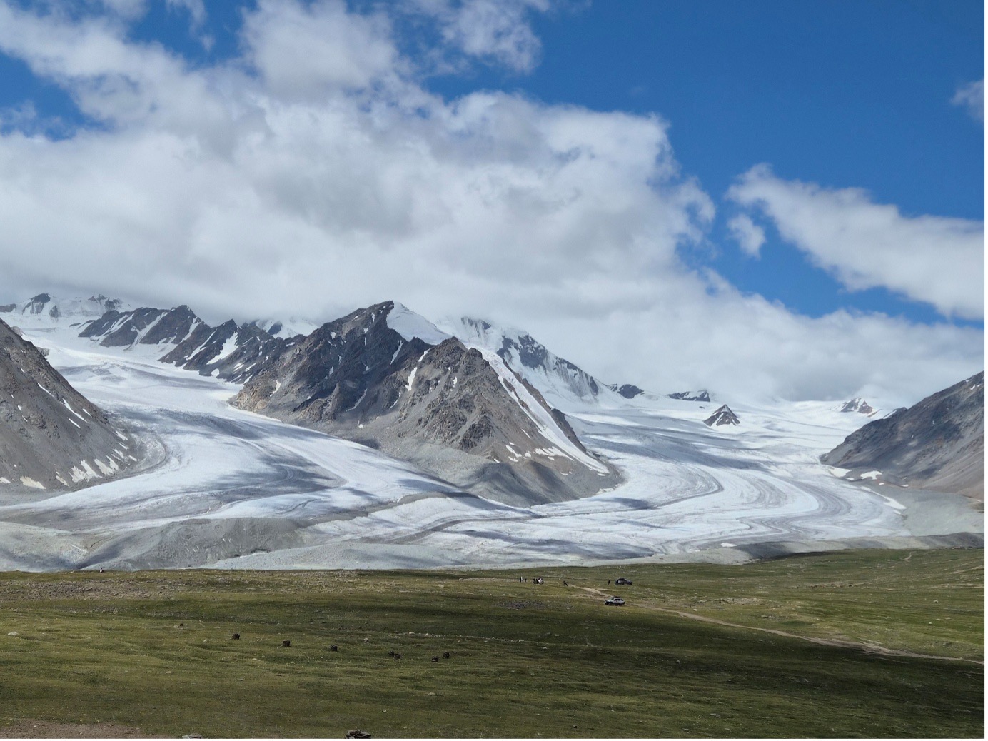
그림 1. 몽골 알타이산 인근 빙하. 몽골 서부지역에서는 빙하와 동토의 용융 속도가 급속히 빨라지는 모습이 관찰되고 있다.
jinhoahn@snu.ac.kr |
|
|
아래는 영국 사이언스 미디어 센터(UK SMC)에서 수집한 전문가 의견입니다. 영국 SMC 홈페이지에서도 보실 수 있습니다. |
|
|
Dr Fatima M. Pillosu, hydrometeorologist and flash floods researcher from the Department of Meteorology, University of Reading, said:
“Everyone in a mountain valley faces the same hazards, but tourists are more vulnerable because they may not recognise the danger or understand local warnings. Visitors from regions where such events are rare may not appreciate how fast a mountain river can rise, nor that these valleys also face avalanches, landslides and floods from melting glaciers, even in dry weather. Knowing in advance what can happen, and what to do if it does, is one of the most useful protections.
“A flood thick with mud and rock can be even more lethal than a rain-fed flash flood. Both can strike with great force and speed and carry boulders and debris along. Fast flowing water can easily pick up anything in its way and carry it off downstream. Mud simply buries people. The moving mass is much heavier than water, and it grows heavier as it travels, scouring soil, gravel and boulders from the riverbed and banks and carrying them along.
“The boulders it carries can destroy buildings and bridges that a water flood might have left standing. When the flow stops, the mud and rock settle into a dense mass that is hard to dig through, making rescue even slower and more difficult.”
Dr Jeff Da Costa, Researcher in Hydrometeorological Hazards, Early Warning & Disaster Risk, University of Reading, said:
“For early warning, you do not always need to know exactly what has happened upstream before taking action downstream. A sudden and unusual change in the river can be enough to warn communities while the cause is being established.
“This is particularly important because the same river corridor experienced a major flood originating in Tibet in July 2025. After that event, Nepalese flood forecasting officials said they had received no advance warning from China and that there was no mechanism in place for sharing that information. Nepal subsequently committed to strengthening coordination with China. We do not yet know what information was available before today’s flood, when it became available or how it moved across the border. Establishing that timeline will be important, including what changed after the 2025 event and how much time communities had to act.
“Early warning in transboundary river basins depends on international cooperation. Monitoring can take place in one country while communities at risk are across the border. Rapid information sharing and trusted communication between neighbouring countries are part of the warning system. This has wider relevance. Many communities around the world depend on environmental information from across a border. Where relations are unstable or cooperation is limited, maintaining those channels becomes critical.
“Events like this can be extremely difficult to predict precisely. Warning systems need to work under that uncertainty by recognising danger quickly, sharing information and having agreed actions that can begin before the exact cause is known.”
Prof Liz Stephens, Professor in Climate Risks and Resilience, Department of Meteorology, University of Reading, said:
“Most people think of flash floods as being caused by heavy rainfall, but in Nepal and Tibet, as in many other high-mountain regions, they can also result from complex chains of hazards, including landslides, avalanches and glacial lake outburst floods. This complexity makes early warning especially difficult.
“Initial reports from Nepal suggest that an earthquake occurred around the same time as a landslide or avalanche, which then led to the catastrophic flooding. One way this can happen in steep mountain valleys is when a landslide blocks a river, allowing water to build up behind it. If that landslide dam, then fails, it can cause a sudden, devastating release of water and sediment downstream.”
Declared interests
Dr Jeff Da Costa: “I have no conflicts of interest to declare. “
Prof Liz Stephens: “No conflicts. Liz also works for the Red Cross Red Crescent Climate Centre.”
For all other experts, no reply to our request for DOIs was received. |
|
|
아래는 호주 사이언스 미디어 센터(AUS SMC)에서 수집한 전문가 의견입니다. 호주 SMC 홈페이지에서도 보실 수 있습니다. |
|
|
Dr Soniya Rijal is a postdoctoral research associate in the School of Project Management at the University of Sydney. She is Nepalese, from Kathmandu. Her research expertise includes disaster management, with a focus on how communities organise around extreme events and build resilience ahead of unforeseen disasters.
"The disaster has impacted three districts: Rasuwa (the epicentre of the disaster) on the Nepal-Tibet border, Nuwakot (located southwest of Kathmandu), and Dhading. All are heavily residential. Rasuwa is a popular trekking spot and international trading hub with a large local community. Bridges connecting the trade routes from China to Kathmandu have been destroyed, including the highways, severely limiting the flow of goods and services to the impacted areas. Roads have been destroyed, so helping local communities will be difficult. Helicopters have been deployed by the Nepalese government to help those who are stranded. We can’t really see at this early stage how many people have been impacted; it’s possible the impact could be even more devastating than the 7.5 magnitude earthquake that struck Nepal in 2015. I’ve heard people were notifying neighbours to leave before the flooding hit, but because there was no rain leading to the flash floods, many of these warnings weren’t taken seriously. What makes this disaster unusual is that it was so sudden, coming without warning. The immediate priority should be to search for missing people, and local communities can help do this. Nepal is a very collective society, and locals will have a better idea of how to locate missing people than those without local knowledge. Shelter and food will be essential to meet immediate needs. Local communities can work with agencies to oversee the logistical hurdles to deliver essential goods and services. They will also be key to mapping the location of available shelters and storage facilities, e.g. schools, gumbas (Buddhist monasteries) in the immediate aftermath of this disaster. These facilities will be important distribution centres for essential goods and services, and serve as community hubs.”
Soniya has not declared any conflicts of interest.
Soniya is contactable on +61 450 626 543 or at soniya.rijal@sydney.edu.au
----------
Associate Professor Nader Naderpajouh leads the Organising Risk and Resilience research lab and is Head of the School of Project Management at the University of Sydney.
"This is a very unique disaster, in terms of intensity and speed, which had a distinct blueprint of impact on communities, and activities around immediate response and recovery. The reports suggest the flood and landslide were caused by a buildup of water in the glacier, which was triggered by seismic activity.
This unique event may trigger the implementation of future warning systems, which is feasible with current state-of-the-art technology. At least the buildup of water can be an early warning sign for downstream communities, a form of seasonal warning for preparation. Such communications and preparations can save lives and reduce the impact at scale.
With global warming, there is an expectation that similar patterns of disasters will recur. We can benefit from the implementation of a warning system, similar to those triggered for tsunami warnings after 2004's tsunami.
The long-term recovery can focus on connecting communities isolated by this disaster. In essence, the priority is to provide baseline infrastructure and connections, so the close-knit communities Soniya mentioned can self-organise their response.”
Nader has not declared any conflicts of interest.
Nader is contactable on +61 484 241 228 or at nader.naderpajouh@sydney.edu.au
----------
Previously issued comments:
Dr Ruth Gamble is Director of La Trobe Asia at La Trobe University and an Environmental Historian
"Scientists from ICIMOD in Kathmandu and China's earth science agencies are suggesting that there was an outburst flood-landslide on the Nepal side of the border in the Everest region that travelled into the Tibetan Autonomous Region before charging down the Bhote Koshi River into Nepal. It operated like an inland Tsunami, travelling nearly 170 kilometres down the Bhoti Koshi valley into Central Nepal. This is the main highway joining Kathmandu to Lhasa, and it is a popular route for international tourists travelling from Kathmandu to Lhasa. I was going to take this route on Sunday."
Ruth has not declared any conflicts of interest.
Ruth is contactable on WhatsApp: +61 484 333 485
----------
Mr Andrew Gissing is the CEO at Natural Hazards Research Australia
"The flash flood disaster in Nepal is tragic. Though the exact cause of the event requires further investigation, the steep and narrow valleys in the region would contribute to its devastating nature of deep, fast flowing and debris laden water. The Himalayan Region has had a history of deadly flash floods. The event appears to have occurred without warning, catching those downstream unaware. Research shows that early warning saves lives and there are efforts globally to improve early warning systems. Attention of authorities will now shift to downstream search and rescue and relief for communities impacted."
Andrew has not declared any conflicts of interest.
Andrew is contactable via Joanna Wood Freeman at joanna.wood@naturalhazards.com.au or +61 430 633 234.
----------
David Sanderson is Inaugural Judith Neilson Professor of Architecture at UNSW and Founder and lead at HowWeSurvive
"This is a terrible and overwhelming event, triggered by natural phenomena and worsened by the location of villages along the river edge. Right now, the focus is on life-saving and getting aid to those affected, including food, water, shelter, warm clothes and blankets. As with many Himalayan disasters, access can be a problem. The best thing aid agencies can do is to support the efforts of local organisations."
David has not declared any conflicts of interest.
David is contactable on +61 42 487 1966 or at david.sanderson@unsw.edu.au
----------
Dr Adrian McCallum is Discipline Lead in Engineering at the University of the Sunshine Coast, and a Glaciologist and Polar Engineer
"I’m yet to fully appraise myself of the situation, but these floods are probably 'glacial lake outburst floods' (GLOFs); these are increasingly common in alpine regions globally as our climate changes. As glaciers melt and recede, ice turns to water, the water is stored (temporarily) behind natural moraine dams, but when those dams breach, tremendous amounts of water can be released down a valley, taking out everything in its path. I was meant to be in the Indian Himalaya now, studying GLOFs, with Indian glaciological colleagues."
Adrian has declared no conflicts of interest.
Adrian is contactable on +61 422 433 638 or mccallu@usc.edu.au
|
|
|
아래는 뉴질랜드 사이언스 미디어 센터(SMC NZ)에서 수집한 전문가 의견입니다. 뉴질랜드 SMC 홈페이지에서도 보실 수 있습니다. |
|
|
Dr Tom Robinson, School of Earth and Environment, University of Canterbury, New Zealand, comments: Contact: +64 22 458 4342, thomas.robinson@canterbury.ac.nz"The images and videos of massive flash flooding in Tibet and Nepal are horrific, demonstrating the power of such natural hazards. At this stage, there is still much uncertainty over what has happened. From the reports we currently have, it appears that a large landslide has occurred somewhere in Tibet causing part of a glacier to collapse and cascade down the valley for many tens of kilometres. The landslide and glacier collapse itself must have been extremely large – seismic networks in the region recorded the landslide impacting the valley floor as a magnitude 4 earthquake. "Unfortunately, these kinds of events are not uncommon in the Himalaya. We’ve seen similar massive landslides and floods in the region before: in 2021 two separate events caused huge damage in Melamchi, Nepal and Chamoli, India. Linking these disasters directly to climate change is difficult, however we know that the Himalayan region is already experiencing dramatic effects from our warming world. Glaciers in the region are rapidly melting and destabilizing and when large landslides, which are common in the Himalaya, fall onto them, they can trigger huge rock and ice avalanches that can travel massive distances. "The first order impacts from these types of events are obvious from the images and videos – tragically we should be prepared for large numbers of fatalities, with early reports already indicating several hundred people have been killed or are missing. There are also likely to be longer term effects as the flood has wiped out critical infrastructure in the valley, including roads, bridges and hydropower stations. Getting access and basic amenities to the affected region will be a significant challenge and it’s clear that this requires a major humanitarian response in one of the poorest countries in the world." Conflict of interest statement: "No conflicts to report." |
|
|
한국과학기술미디어센터(SMCK) 소개
한국과학기술미디어센터는 근거 기반의 과학 정보를 언론에 제공하는, 과학계와 미디어 사이의 다리 역할을 하는 독립 비영리 조직입니다. 잘못된 정보와 가짜 뉴스가 넘쳐나는 세상에서, 제대로 된 전문가의 해설과 의견을 빠르고 다양하게 기자들에게 제시하고 이를 체계적으로 아카이빙하는 역할을 합니다.
2025년 7월 이사회를 구성하고(이사장 노정혜 전 한국연구재단 이사장) 센터장(이근영 전 한겨레 과학전문기자)을 선임했으며, 같은해 9월 개소식을 열며 활동을 시작했습니다.
*참고 기사:
SMCK 역할
SMCK는 세 분야 전문가인 과학자, 기관 커뮤니케이터(홍보팀), 기자에게 구체적인 도움을 드리고자 설립됐습니다. 각각 아래와 같습니다.
- 과학자, 연구자에게는 의견과 해설이 온전한 맥락과 함께 제공되는 안전한 발언 공간이 돼줍니다. 선의를 위해 한 논평이 기사화 과정에서 왜곡되거나 부정확하게 변질될 우려를 줄이는 완충 작용을 합니다.
- 기관 홍보 담당자에게는 기관의 성과를 기자들에게 보다 객관적이고 정교하게 알리고, SMC 글로벌 네트워크를 통해 영향력을 높일 기회를 제공합니다.
- 기자에게는 사안을 해석하는 데 도움이 될 치우침 없는 종합적인 정보를 빠르고 풍성하게 제공하고, 이를 통해 기사에서 과학과 기술을 보다 자유롭고 편리하게 활용하도록 돕습니다.
SMCK는 이를 통해, 궁극적으로 근거에 기반해 사안을 합리적으로 판단하고 이것이 정책에까지 반영되는 사회를 만드는 데 기여하고자 합니다.
해외 협력
사이언스미디어센터(SMC)는 2002년 영국에서 최초로 설립됐고 현재 호주와 뉴질랜드, 독일, 스페인, 대만, 아일랜드 등으로 확장됐습니다. 한국은 2025년 12월, 7번째 센터로 합류했습니다. 글로벌 네트워크에 포함된 8개 조직은 엄격한 독립성과 신뢰성이라는 가치를 공유하고 있으며 협력을 통해 주요한 국제 과학 이슈에 공동 대응하고 있습니다.
|
|
|
* 지난 의견은 '지난 의견 다시 보기'를 선택해주세요. |
|
|
내용문의: 윤신영 미디어국장 yoonsy@smck.or.kr
비상 연락(당직 전화): 010-4440-5450
한국과학기술미디어센터(SMCK)
|
|
|
|
|